Fort Siloso: Batteries & Defences: Buona Vista 15 Inch BL Battery. What Remains Today?

The Buona Vista Battery - What Remains Today?
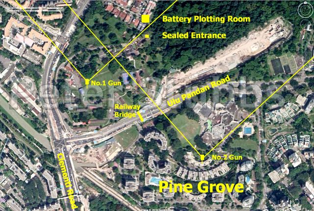 LEFT: The Location of the Buona Vista Battery overlaid on a Google Earth View of the area. The yellow lines show the arcs of fire for the guns.
I’ve compared map references and Trunnion levels (height above mean sea level for the swivel points of the barrels) of each of the guns on period and later British Ordnance Survey maps, and with more modern maps. I’ve also compared period photos with recent ones of the area to try to be accurate.
In addition, I've been sent photos and information from some helpful people in Singapore.
From all of this, I’m quite confident that I have marked the Guns within a few metres of the actual locations.
LEFT: A sealed entrance in the KINS Camp, not far from where I believe the No.1 Gun was. This is of similar proportions to the entrance of the ‘Battlebox’ at Fort Canning The entrance could possibly lead to an underground command post such as was once near the No.2 Gun at the Johore Battery in Changi. Alternatively, it could have been an artillery store. The visible concrete looks to be of an age equalling the date of the Battery.
No.1 Gun: I am confident that there are remains of the No.1 Gun Emplacement underground. These consist of the Shell Store, Cartridge Store, and the Power House.
No.2 Gun: In early 2010, a sink-hole appeared in the arc formed by Block 1M at Pine Grove. The hole was very deep, and there was evidence of a concrete structure going around it. The following year, a survey of the area was conducted using ground penetrating radar. There is a very strong evidence from this that there is a substantial underground construction in the arc formed by the block. There are also many interesting depressions on the surface, which I examined during a site visit.
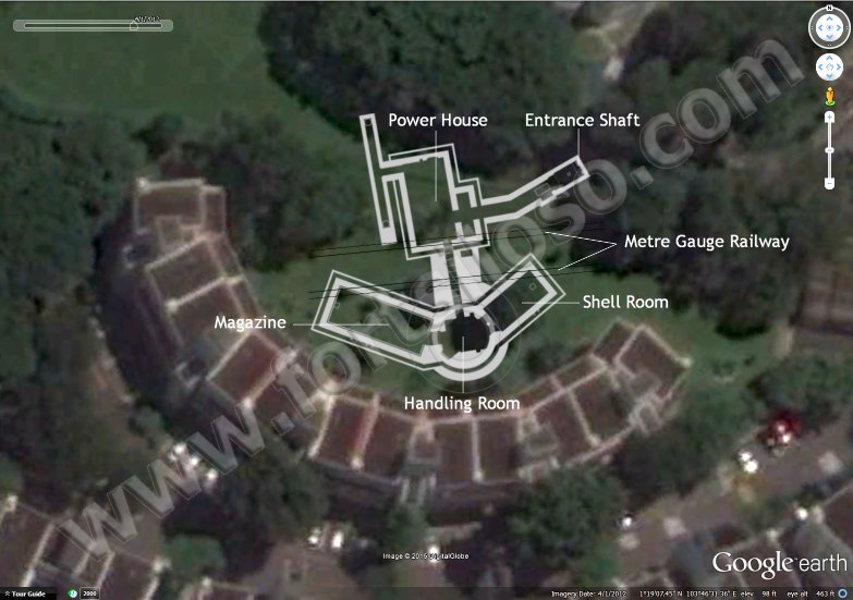
The No.2 Emplacement as it may be underground today
The arc formed by Block 1M is the calculated location of the Buona Vista No.2 Gun. I calculated it using original map references, and triangulation using features still remaining today — bridges for instance. Aerial photos were also used. Triangulation angles and distances were transferred to a modern map (Not Google, Bing, or other street maps) to improve accuracy. It is possible that the sinkhole was created by many years of rain dispersing the smaller parts of the fill of the gun well into the rooms and passage below. The gun well was some 10·6 metres internal diameter and 8·83 metres down to the floor of the Handling Room below.
The underground structure in the image is drawn very close to scale, and is in the correct orientation of 170°. Much of the concrete used to construct the gun battery has been omitted from the diagram for clarity. The No.1 Gun’s underground structure was identical, although the entrance passage was slightly shorter.
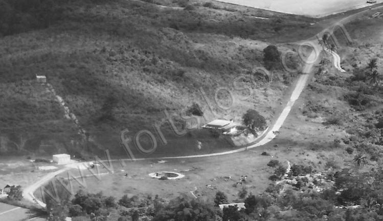
1960s photo of the Pine Grove Area. No.2 Gun Well left of centre at the bottom
The photo above shows the area of Pine Grove and the Nexus International School in the 1960s. The hill is long gone for land reclamation. The building above and to the right of the gun well were probably accommodation for the Gunners. Traces of the railway lines are just visible, and just beyond the gun well is a light patch which may have been the entrance shaft to the underground areas. Other patches may be the hard standing for cranes.
The last of the military railway
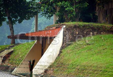
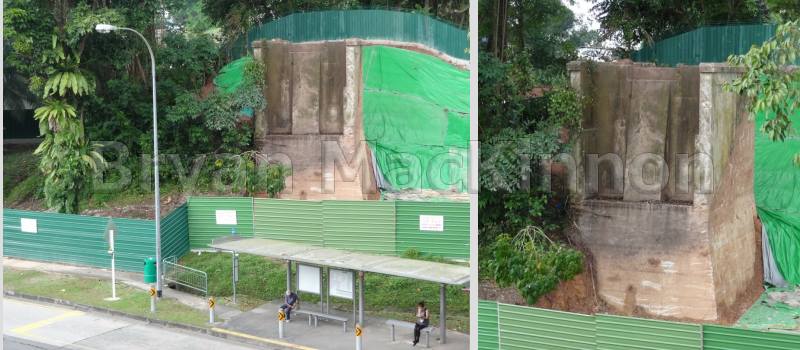
Railway: Late in 2012, workmen engaged on the widening of the Ulu Pandan Canal uncovered a bridge support shown above outside the KINS Camp. This is all that remains of the military railway servicing the guns. A similar support will have been on the other side of the road. They supported a Truss Bridge.
Sealed Entrances & Battery Plotting Room: The sealed entrance indicated in the image at the top of the page, is almost certainly an entrance to the Battery Plotting Room. I have been reliably informed of several other sealed entrances on the slopes inside the camp. One of these may be a second entrance to the Plotting Room. Others may have lead to storage chambers. As to the Battery Plotting Room, does any of that remain below the houses on Clementi Crescent? As it was underground, have the foundations of the houses destroyed it, or aren't they deep enough?